Local Families
Interview with Sue Martel. Sue lived at Middleton Lodge with her parents Jock and Jill Ropner from 1946 until her marriage in 1957. Her parents continued to live there until 1980
Village Buildings - Descriptions of selected buildings within the village, using the Village Green as the central point.
Village Features
WI Garden behind Village Shop - This garden was designed and developed in 2004 by the Middleton Tyas Women's Institute (with a little help by 'willing' husbands).
Tithes
What were tithes?
Tithes were a local tax on agricultural produce. This tax was originally paid by farmers to support the local church and clergy. When Henry VIII abolished the monasteries in the 16th century, many Church tithe rights were sold into private hands. Owners of tithe rights on land which had previously belonged to the Church were known as ‘Lay Impropriators’. Tithe charges were extinguished in 1936.
What is a tithe map?
Disputes over the assessment and collection of tithes were resolved by the Tithe Commutation Act of 1836. This allowed tithes in kind (wheat, hay, wool, piglets, milk etc.) to be changed into a fixed money payment called a ‘tithe rent charge’. Detailed maps were drawn up showing the boundaries of individual fields, woods, roads, streams and rivers, and the position of buildings. Most tithe maps were completed in the 1840s.
What is a tithe apportionment?
The details of rent charges payable for each property or field were written up in schedules called ‘tithe apportionments’ . This part of the tithe award recorded who owned and occupied each plot, field names, the use to which the land was being put at the time, plus a calculation of its value.
Why are tithe records useful?
Tithe maps are very important because they are often the first large scale map of a particular area. The apportionments are a detailed inventory of farming and land use in the mid-19th century.
Where can I find tithe records?
Three originals of each tithe map and award were produced. The Tithe Commissioners’ copy is now held at the National Archives in London. In most cases one or both of the two copies made for the local Church authorities are now held in local archives. This guide lists surviving diocesan and parish copies of tithe records held by West Yorkshire Archive Service
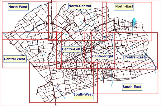
<<<Please click on the map for a larger version.
1841 Tithe Map and Field Names
North West
North-Central
North East
Central West Same as Centre East
Centre-Left
Centre-Right Same as Centre Left
Central East
South-West
South-East
1845 Tithe Apportionments List
Unfortunately there is no accompanying map for the 1845 Tithe survey, however the field names are the same (where they exist)m as the 1841 maps above. This list shows the land owner, tenant, lot (field) number, lot description and acreage as well as totalling the acreage for each land owner.
1755 Census
Parish Records Statistics showing Baptisms (Births), Burials (Deaths) and Marriages for the period of 1641 to 1800
Field Systems Map of Middleton Tyas Parish showing ridge and furrow and lynchetts, surveyed 2010